Day 2 is in the books. Today was also a great day. The 3D Studio Max classes were great. I finished out the day at the Blogger/Social Media event. Great times with good friends and meeting new friends.

Thursday, December 4, 2014

Wednesday, December 3, 2014
Day 1 of Autodesk University 2014
Day one is in the books. The classes were great. There are exciting new things coming down the pipeline. Day two should be just as fun.
Tuesday, December 2, 2014
Autodesk University 2014
Autodesk University 2014 is in full swing! The first class is over and now on to the Keynote Session.

Sunday, November 9, 2014
How to Import GIS Soils Data and Soil Type Labels into Civil 3D 2015
For this exercise, I have downloaded soils data
from the United States Department of Agriculture web site. http://websoilsurvey.sc.egov.usda.gov
2. Create a new Soils layer and Soils Label layer. I’m using layer names for this exercise. C-SOIL-E and C-SOIL-IDEN-E.
3. Change the drawing Coordinate System to the project location.
4. Importing the Shape file (*.shp) data.
a. Type MAPIMPORT at the command line.
b. Change the file type to ESRI Shape file (*.shp).
c. Select the soilmu_a_aoi.shp file.

5. Change the following settings in the Import Dialog box.
a. Set the Drawing Layer..
b. Check “Import polygons as closed polylines”.
c. Add a data field by clicking in the data cell and the box on the right.

d. In the Attribute Data dialog box, click the “Create object data” radio button.

e. Click Ok to get back to the Import Dialog box.
f. Click Ok again to import the data.
g. Zoom extent to view the imported line work.
h. Save the file. I’m saving the file to C:\temp for easy access of the labeling steps. I named the file USDA Soils.dwg.
i. Close the file.

2. Create a new Soils layer and Soils Label layer. I’m using NCS layer names for this exercise. C-SOIL-E and C-SOIL-IDEN-E.
3. Change the drawing Coordinate System to the project location.
4. Change the Civil 3D workspace to “Planning and Analysis”.
5. Open the “Map Task Pane” from the View tab on the Ribbon.
6. Click the “Map Explorer” tab on the Map Task Pane.

7. Attach the USDA Soils.dwg drawing saved from the Importing the Soils Data steps by right clicking on the “Drawings” folder on the Map Task Pane.
8. Click Attach.

9. The file is located in C:\temp.
10. Click USDA Soils.dwg and then click Add.
11. Click OK.

Now the file is attached to the current drawing. We have to execute a query to import the soils and labels.
2. Click Define.

3. Click the Location button.

4. Click the “All” radio button then click Ok.

5. Click the “Draw” radio button under Query Mode.
6. Check the box under Options and click the Alter Properties button.

7. Click the Layer radio button.
8. Click the “Values…” button and select the C-SOIL-E layer.
9. Click Ok.
10. Click the “Add” button.

 11. Do
not close the Alter Properties dialog box.

2. In the Define Text Dialog box, click the “Expression” button.

3. Expand the Object Data folder then click MUSYM data field.
4. Click Ok.

5. Set the text style, text height and layer.
6. Click Ok.

7. Click Ok to close the Set Property Alterations.

8. Click the Execute Query button.

9. Zoom extent to view the imported line work and labels.
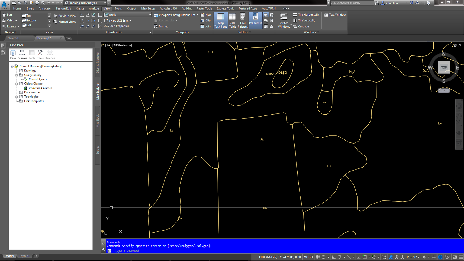
10. In Map Explorer, right click on the attached c:\Temp\USDA Soils.dwg.
11. Click Detach.

12. Save drawing.
13. The labels may have to be moved for better presentation.
Let me know if you have any questions.
Importing the Soils Data
1. Start
a new drawing.2. Create a new Soils layer and Soils Label layer. I’m using layer names for this exercise. C-SOIL-E and C-SOIL-IDEN-E.
3. Change the drawing Coordinate System to the project location.
4. Importing the Shape file (*.shp) data.
a. Type MAPIMPORT at the command line.
b. Change the file type to ESRI Shape file (*.shp).
c. Select the soilmu_a_aoi.shp file.
5. Change the following settings in the Import Dialog box.
a. Set the Drawing Layer..
b. Check “Import polygons as closed polylines”.
c. Add a data field by clicking in the data cell and the box on the right.
d. In the Attribute Data dialog box, click the “Create object data” radio button.
e. Click Ok to get back to the Import Dialog box.
f. Click Ok again to import the data.
g. Zoom extent to view the imported line work.
h. Save the file. I’m saving the file to C:\temp for easy access of the labeling steps. I named the file USDA Soils.dwg.
i. Close the file.
Add the Soils Labels
1. Start
a new drawing.2. Create a new Soils layer and Soils Label layer. I’m using NCS layer names for this exercise. C-SOIL-E and C-SOIL-IDEN-E.
3. Change the drawing Coordinate System to the project location.
4. Change the Civil 3D workspace to “Planning and Analysis”.
5. Open the “Map Task Pane” from the View tab on the Ribbon.
6. Click the “Map Explorer” tab on the Map Task Pane.
7. Attach the USDA Soils.dwg drawing saved from the Importing the Soils Data steps by right clicking on the “Drawings” folder on the Map Task Pane.
8. Click Attach.
9. The file is located in C:\temp.
10. Click USDA Soils.dwg and then click Add.
11. Click OK.
Now the file is attached to the current drawing. We have to execute a query to import the soils and labels.
Importing the Soil Polylines
1. Right
click “Current Query” on the Map Task Pane.2. Click Define.
3. Click the Location button.
4. Click the “All” radio button then click Ok.
5. Click the “Draw” radio button under Query Mode.
6. Check the box under Options and click the Alter Properties button.
7. Click the Layer radio button.
8. Click the “Values…” button and select the C-SOIL-E layer.
9. Click Ok.
10. Click the “Add” button.
Importing the Soil Labels
1. Click
the “Text” button.2. In the Define Text Dialog box, click the “Expression” button.
3. Expand the Object Data folder then click MUSYM data field.
4. Click Ok.
5. Set the text style, text height and layer.
6. Click Ok.
7. Click Ok to close the Set Property Alterations.
8. Click the Execute Query button.
9. Zoom extent to view the imported line work and labels.
10. In Map Explorer, right click on the attached c:\Temp\USDA Soils.dwg.
11. Click Detach.
12. Save drawing.
13. The labels may have to be moved for better presentation.
Let me know if you have any questions.
Friday, October 31, 2014

Monday, September 29, 2014
Friday, September 5, 2014
Monday, August 4, 2014
This is not CAD or Autodesk related.
Please join my son's 5k team or donate to help fund the Down Syndrome Association of Greater Richmond. My son Ryan was born with down syndrome. He is three years old and we are raising money to support the Down Syndrome Association of Greater Richmond.
http://www.firstgiving.com/team/270582
Thanks,
Vince
Please join my son's 5k team or donate to help fund the Down Syndrome Association of Greater Richmond. My son Ryan was born with down syndrome. He is three years old and we are raising money to support the Down Syndrome Association of Greater Richmond.
http://www.firstgiving.com/team/270582
Thanks,
Vince
Subscribe to:
Posts (Atom)